Careful planning at the core of responsible forestry
A precondition for responsible forest use is accurate and comprehensive data on natural resources and a sustainable level of their exploitation. This requires thorough knowledge of the operating environment and an ability to anticipate changes in it. In particular, the impacts of timber harvesting and forest regeneration on nature, climate and the lives of other users of the area must be taken into consideration.
The state’s land and water areas are the focus of many types of needs and wishes regarding their use. Metsähallitus has the important task of coordinating these needs and wishes through planning process called Natural Resource Plan, including the landscape ecological plans.
Regional natural resource plans
In short
• Natural recources planning
is an instrument for long-term management of large forest areas
• Landscape ecological planning
– valuable habitats and other special areas mapped
• Logging and silviculture plans
according guidelines for operation
• Public participation
– social licence to operate
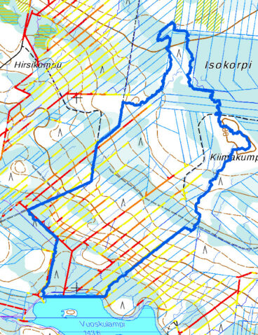
Regional natural resource plans are strategic plans on the use of natural resources of the certain area. The plans define the main operational policies and land use solutions that support them. For example, the natural resource plans contain felling plans for commercial forestry.
The regional natural resource plans are drawn up in close collaboration with a cooperation group that represents stakeholders in the relevant region.
Public participation is the means to provide the local people and interest groups the possibilities to influence their living surroundings and to take into account the traditional uses of state lands. State forest management needs to be more open and participatory than private forestry.
Before a natural resource plan is prepared, the stakeholders elect a representative cooperation group to formulate and select different planning options. During the process, all interested parties are given the opportunity to have a say through online feedback and at public events.
Landscape ecological assessment
The natural resource planning process also includes a landscape ecological assessment, in which forest area is viewed in a big picture consisting of
the protection areas, recreation and other special areas and multiple use forests.
Landscape ecological plan is a multitarget forest plan which combines ecological targets to maintain biodiversity and the management of multiple use of forests.
No forestry on valuable habitats
In landscape level the network consists of core areas, ecological connections and support areas. Nature sites and other set aside and restricted forestry areas in multiple use forests are planned to supplement the protection areas and develop biodiversity entities. Forestry operations are restricted in these areas, or they are excluded from commercial forestry use.
Key biotopes are saved and their valuable structural features (decaying wood, burned wood, old trees, uneven tree stands etc) are thus maintained.
In addition to safeguarding biodiversity, another aim of landscape ecological planning is to safeguard possibilities for the multiple use of forests and pursuit of natural sources of livelihood.
Consequently, the landscape ecological plans also cover game habitats, landscape values and cultural sites. In Northern Finland, the needs of reindeer husbandry are a high priority. Possibilities for recreational uses of nature are addressed especially in important tourism areas.
In summary, the aims of landscape ecological planning are:
- to maintain the natural biodiversity of the area in the long perspective
- to enhance multiple use of forests and practising traditional nature-based livelihood
- to safeguard clean water and other regulation and support services
Read more about planning of state-owned areas.
Operational planning in forestry
Metsähallitus has an advanced planning tool based on a geographic information system (GIS) with comprehensive data on state-owned land. It includes for example:
- current land use objects
- species data
- various different kind of forestry data (habitat- and tree stand data, forest roads, lidar scanning material, operational data like planned and executed measures)
- recreational trails and facilities
- various special values, such as occurrences of endangered species, valuable habitats, cultural heritage sites and landscape and game sites.
Using an up-to-date GIS system in various phases of operational planning ensures that these special values are taken into consideration in forest use.
Metsähallitus’ geographic information system – perhaps the most extensive in the world – forms the basis of planning at Metsähallitus. The volume of information in the system is constantly increasing, enabling even more detailed and in-depth planning.
Gathering and using data
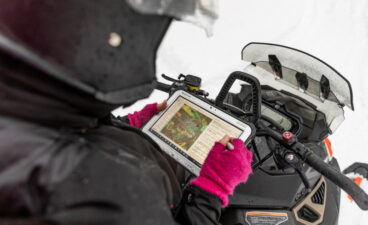
A Forest Specialist (A Planner) working in the field uses a hand-held computer which contains data on the planning area downloaded from the geographical information system. Up-to-date information on sites as well as habitats, biotopes and forest management can be read on the screen right in the forest.
Site data is collected through observation, surveys and assessments in the field. The Forest Specialist updates and enters into the site records any information on an area’s compartments, takes note of fellings, forest management operations and their timing, and marks any changes on a printed map. While visiting the site, the
Forest Specialist demarcates land areas and regeneration felling sites, marks retention tree groups and verifies the land use and habitat information of compartments.
Forest management and logging planning
Once the site data has been collected, the Forest Specialist’s work continues in the office. Compartment data updates and proposals for measures are electronically transferred from the hand-held device to the geographic information system. The Forest Specialist makes compartment demarcation changes on his or her own computer terminal, enters them into the system and calculates the volume of harvested stands.
A detailed action plan is created when the Forest Specialist makes a site map, prints out the landscape ecological map of the area and marks the special areas and felling boundaries on the plan. The Forest Specialist also prints out any required reports concerning the felling sites.
Our felling plans are presented as necessary to such stakeholders as village committees, environmental organisations or tourism businesses. In the reindeer herding area, the co-operation procedures with reindeer herding co-operatives are applicable to all felling sites.
Read more about our stakeholder cooperation.
When the planned work has been carried out on site, the forest’s status is updated in the geographic information system. The geographic information is always kept up-to-date, giving an accurate picture of the forest to facilitate planning.
Other modes of forest use highlighted in special areas
Special areas have been established at destinations experiencing increased levels of recreational use or nature tourism, or which are particularly precious because of their biodiversity or landscape values. The main form of land use in a special area usually is something other than forestry, and the boundaries of the area have been drawn with this in mind.
From the perspective of forestry, the key goal of planning in special areas is management which safeguards the forest cover typical of the site, also over the long term.
We take into account any ecological, cultural and other special sites known to exist in the area. If necessary, we conduct a landscape analysis in connection with the planning to identify sensitive elements affecting the landscape. We also check that any recreational infrastructure and trails are stored in our geographic information system. This way we can plan the time and place of fellings and other forestry operations in the area, also in relation to each other, taking the other land use forms into consideration.
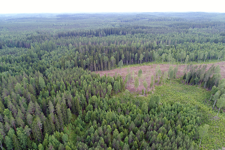
Forest management creates versatile landscapes
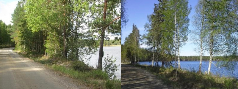
Landscape planning helps reduce landscape impacts from fellings experienced as unsightly. In some cases, fellings can even have a positive effect on the landscape and the recreational value of the forest. When a dense forest is cut, beautiful watercourses and cultural landscapes may be revealed, which liven up and diversify the forest landscape.
Shaping felling areas, selecting the locations of retention trees, opening up views over valuable landscapes and highlighting special sites are some of the forest management tools used to preserve landscape values.
Variation of tree species, and especially a high number of deciduous trees, are important for increasing the landscape value of a forest. In Northern Finland, the wild nature of landscapes popular with tourists can be maintained by means of techniques that preserve forest cover, such as small clearing felling and thinning.
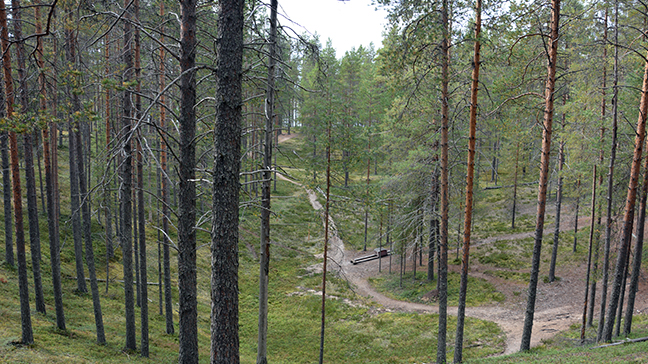
Areas with particularly sensitive landscapes include those with permanent homes and holiday houses, cultural environments, forests near trails and recreational infrastructure, slopes and tops of hills, shores of water bodies and roadsides. Examples of forest management measures suitable for such sensitive areas are selection cutting and planting in small clearings, thinning and retention tree felling.
On sites designated for recreational use, damaging paths and trails is avoided, and any felling residue on trails is picked up. In popular recreation areas, harvesting takes place outside the peak season.